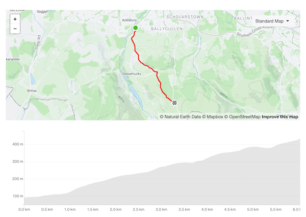
For all its cultural significance, the Hill of Tara is not much of an eminence — in order for it even to scrape into Category 4, you have to include the road approaching the climb proper. At the top of the initial ramp, take the left turn, then right at the next crossroads; both turns are signposted for a cycle route. From there it’s a straight line to the top — it’s a pretty road, lined with hedgerows and mature trees, but it’s so narrow that it will be a tight squeeze if you meet any cars coming in the opposite direction. The steepest gradient comes in the middle of the hill, at around 9%.
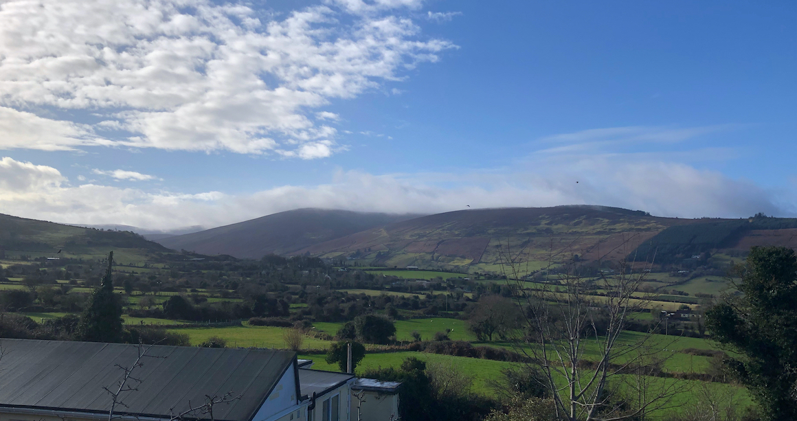
Looking north-east towards Drogheda from the car park at the summit
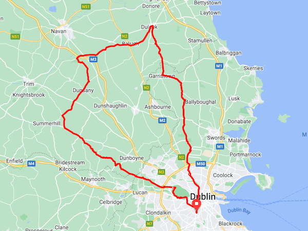
I ride this route about once each year, early in the spring when the training plan calls for longer rides but the mountain roads might still be sketchy. Running through the gentle farmland of north county Dublin and county Meath, it’s eminently suitable for fixed gear riding.
The most tedious aspect of the route is getting out of the city centre — it’s a full 14km of urban traffic until you get to St. Margaret’s. After that you’re mostly on quiet minor roads until you cross the Royal Canal on the way back into Dublin — even then the run through Castleknock and Phoenix Park is one of the more pleasant ways back into the city.
Keep your wits about you when making the turn off the R156 at 85km — it’s on a sharp left-hand bend and you need to go most of the way around to get any view of oncoming traffic.
There are plenty of refuelling opportunities on the way out — there are shops in Oldtown, Garristown, and Duleek, and a petrol station just after you cross the N2 around Balrath. Maguire’s cafe at the top of the Hill of Tara is ideally placed for a lunch stop, more than halfway through the ride, and an easy start afterwards so you can digest a little. It’s probably bedlam during tourist season though.
There’s not much after that — the only business in Dunsany is a piano tuner — but the post office in Kilcloon (88km) has a small shop if your stomach is rumbling.
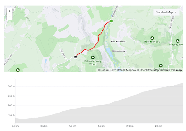
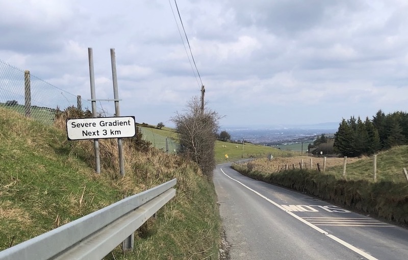
Ballinascorney is a solid climb but it doesn’t inspire genuine love in me. The lower section is nice, winding upwards on a smoothly paved, tree-lined road, but it’s also very narrow, and the quarry at the top of the hill means that you often find yourself being monstered by impatient gravel truck drivers. Further up the road opens out but the surface is harsher and you’re more exposed to the wind.
Nonetheless, I ride it dozens of times every year, and I’m often battling it out for the Local Legend on the Strava segment because it’s the best way out of the city towards the south-west. The Embankment (N81) will take you to many of the same places but traffic is far heavier and there’s no hard shoulder despite it being an N-road. Ballinascorney gives you access to the picturesque roads behind Bohernabreena reservoir, and to essential climbs like the Firing Range and McDonagh’s Lane. It’s usually salted in the winter and carries enough traffic for any frost to melt off quickly so it’s often usable when other mountain roads aren’t.
The road starts climbing as you pass the Bohernabreena Reservoir car park and if you’re lucky enough not to have any cars for company the first kilometer or so is very pleasant. It briefly hits 14% but the road is so smooth that you’d barely notice it. There’s a respite section as you pass the foot-golf course on the left before the road kicks up again and the surface turns into giant sandpaper. The next half-kilometer is the meat of the climb, a steady 9% gradient. The gradient eases off as you swing left and you’d like to shift up but this is usually the moment when you discover where the wind has been hiding, and you crawl the remaining 500m to the top.
I wish you the very best of luck in stealing Nico Roche’s KOM on this segment.
Brother, have you heard the good news?
Ballinascorney comes into its own as a descent. At the crest of the hill you get a brief glimpse of the city spread out below you* as you get into full aero tuck for the ski-slope first half. The lower half is more sinuous and narrow but the curves are still loose enough that you can rip through them faster than cars can drive them. After the shank over the bridge at the bottom of the descent proper the road continues gently downhill all the way back to Rathfarnham and you often have a tailwind into the bargain — you may have been on your hands and knees before then but you’ll feel like a king, big ringing it all the way home.
Piperstown Road is one of my favourite local climbs. Once you’re past Bohernabreena village, the road is very quiet — to see more than a couple of cars along the way up would be unusual. The gradients vary constantly with the steepest ramps hitting 15 and 16%, but the road surface on the upper stretches is billiard table–smooth and you’ll feel like you have an extra couple of gears.
The road starts to rise as soon as you turn off the R114 onto Bohernabreena Road but the fun doesn’t really begin until you pass the church on the right side of the road — a short ramp touching 15%, just to wake you up. The houses lining the side of the road thin quickly as you head up, giving views of the valley to the left.
At 3.5km the road descends briefly, then shanks left and right over a small stone bridge to deliver you straight into the next steep section. You’d like to be able to carry pace into it, but the kink in the road is tight enough to make that difficult. From the bridge on, you’re into the mountains proper, open bogland to your right, pine plantations on the left, and the scars left by a dozen burnt-out cars along the roadway.
Another short drop brings you to the final grind to the top, the junction with Military Road. From there, turn right to continue towards Sally Gap, turn left to drop back down into the city.
Piperstown also makes a very nice descent but during the winter it’s so lightly trafficked that there is often a sheen of moss on the surface of the road that can be treacherous if it’s wet (and it will be). Approach with caution.
Piperstown Road: the final section up to Military Road
Let’s get the ball rolling with something very basic. This is a route I ride mostly in the winter and early spring: the roads are relatively sheltered from the wind, and it packs in a decent amount of climbing for a ride that takes less than two hours. If you’re desperate for a coffee stop (or a pint), Johnnie Fox’s will be happy to take your money.
Head out through Old Bawn on the R114, a road which will soon become tediously familiar. It’s a wide, open drag that offers no respite from the prevailing westerlies but it’s direct and it has the signal virtue of not being the bloody N81.
After the crossroads at Old Bawn, turn left onto the L7114 and follow the road for 6km through Bohernabreena village and up to the Featherbeds. At the T-junction, go left on Military Road to drop down to the Viewing Point, then sharp right onto Cruagh Road.
Take the right turn onto Pine Forest Road and continue past O’Connell’s Rock to the Glencullen crossroads. Turn left onto Red House Road and continue down Burrow Road to join the R117 near Stepaside. From there it’s suburban roads through Dundrum and Terenure to finish.
Variation: turn right after Bohernabreena and follow the road through Glenasmole to join Upper Cunard Road. Continue to the T-junction at Military Road, and turn left to rejoin the original route.