The Firing Range (5.1km, 375m, 7.3%)

Map and Elevation Profile of the Firing Range climb

Strava

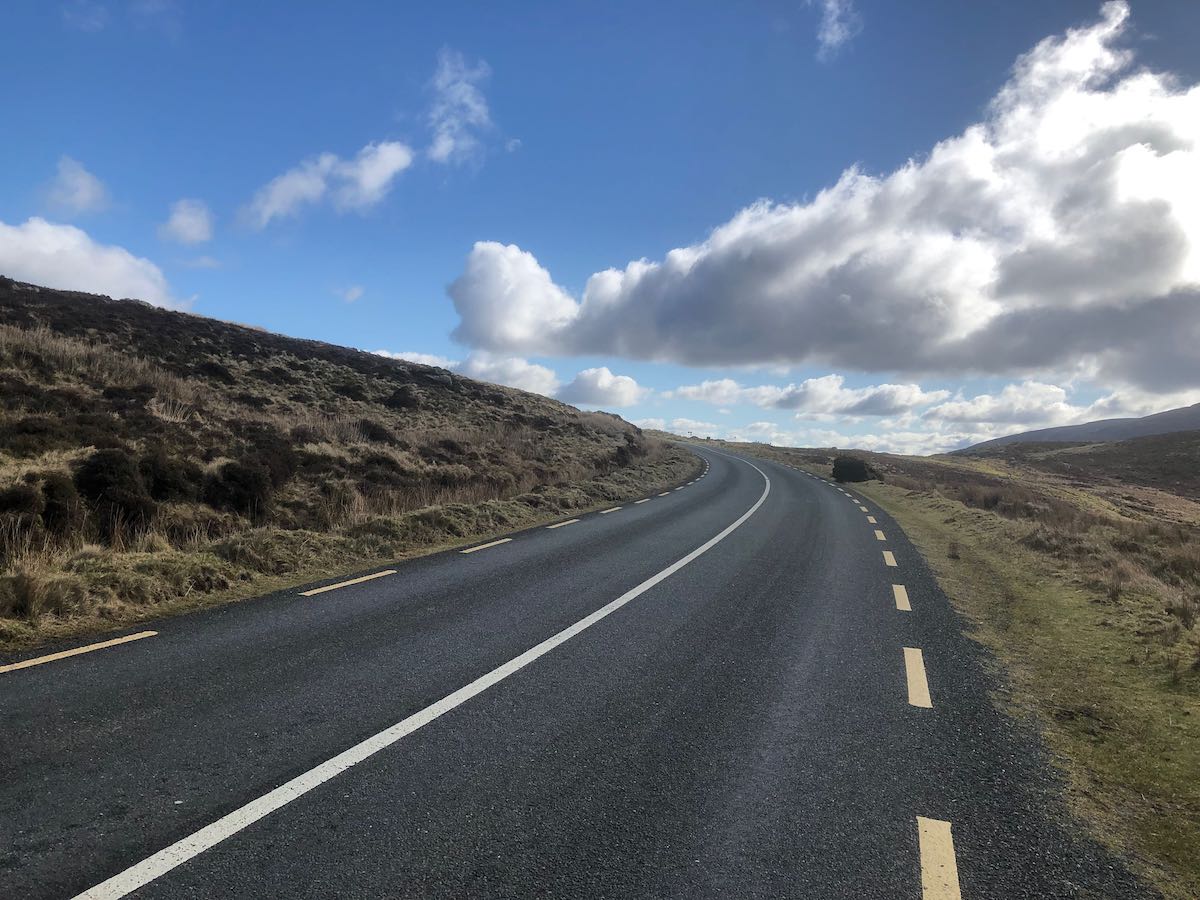
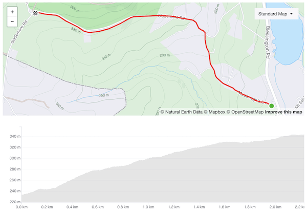
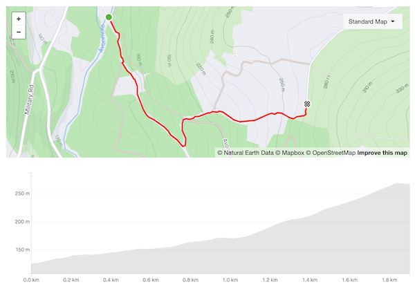
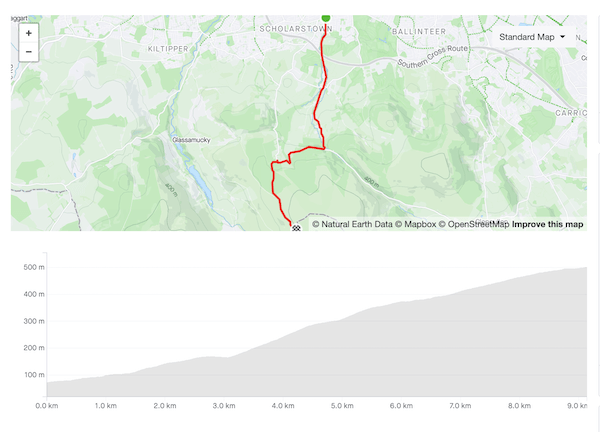
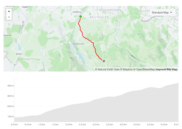
The climb to the Firing Range at Kilbride army camp is my favourite training climb, five kilometres sustained effort, much of it along a quiet, well-paved road. Although it’s a fraction of the length of the marquee climbs in the Alps, the gradients and smooth asphalt are comparable.

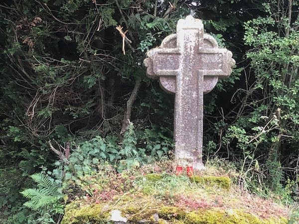
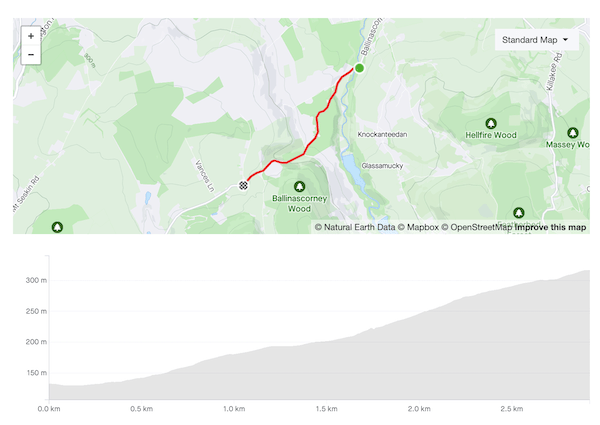
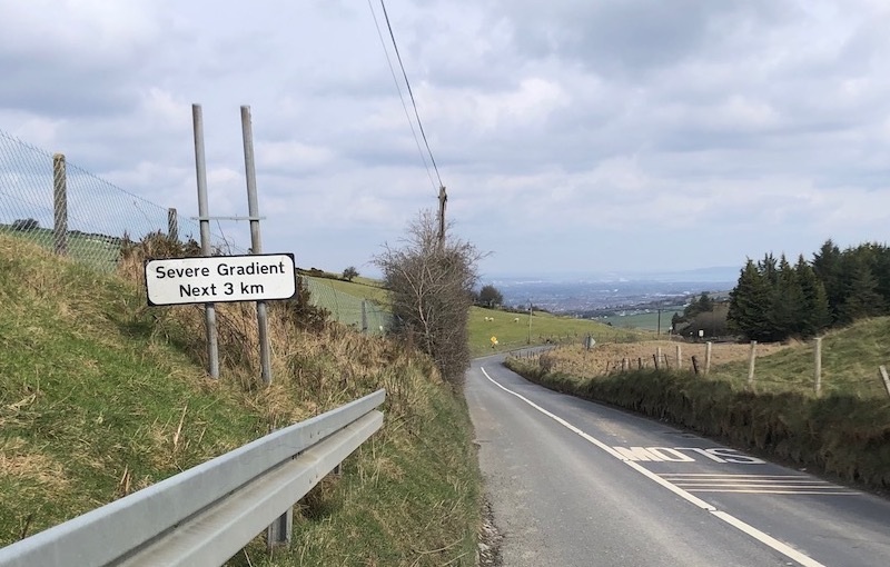
The first couple of kilometers follow the Ballinascorney climb. Near the summit, bear left onto the slip road (signposted for the Lodge, L7462) and stay left past the Famine Cross. The road levels out for a few hundred meters, then ramps up after a small bridge, briefly hitting double-digit gradients before settling at 8–9%. As the trees give way to open land on the left, the gradient eases and you can gear up for the short ramp to the top.

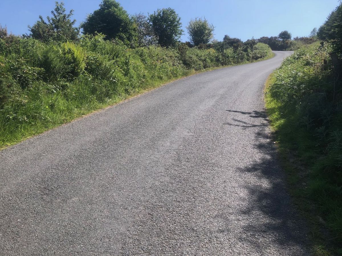
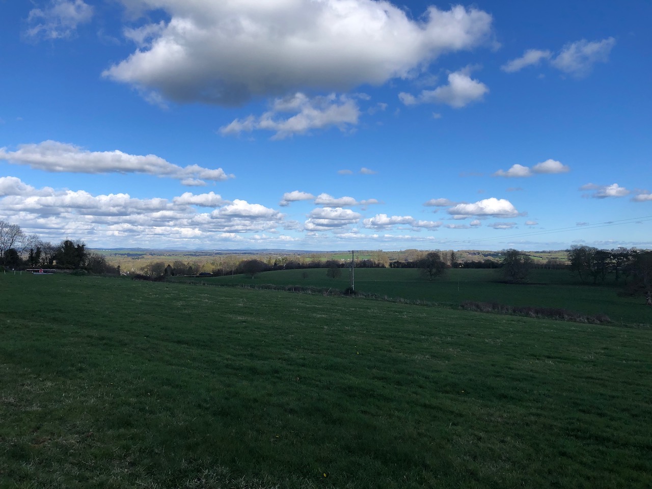
The road is narrow enough at points that cars will struggle to pass, but it’s little used and during the week you can expect to have it entirely to yourself. Settle into the climb and enjoy the ambient soundtrack provided by streams, insects, birds and sheep, and maybe the odd burst of gunfire.

Stone cross on a grassy knoll, commemorating the dead of the Great Famine
The Famine Cross

Wicklow Gap (W) (5.5km, 221m, 3.9%)

Map and Elevation Profile of Wicklow Gap West

Strava

The western approach to Wicklow Gap is undeniably the less attractive option. It lacks any clear starting point: arguably the R756 starts to rise eleven kilometres away, at the bridge across the King’s River below the Hollywood hills, but only when you’re halfway to the Gap does the gradient become visible. You’re definitely already climbing by the time you reach the Quintagh turn-off, but it offers one of the few obvious landmarks on a long, wide road.

For all that road is wide, the lower reaches of the climb are closed in by trees and hillside, and there’s no view to speak of until you’re close to the top, the ground falling away to your right revealing the line of pylons leading up to the ESB station. By then the hardest parts of the climb are behind you, and you can pick up speed as you approach the summit.

For all that, it’s a good climb for early in the year. By whatever quirk of local climate, conditions around Wicklow Gap are generally more forgiving than Sally Gap — you’re less exposed to the gales which in any case funnel up the valley, pushing you up the road. As the main east-west route across the mountains, the road is well-maintained and gets enough sun that frost clears quickly. The gradient is never severe, maxing out at 8–9%, and it’s long enough an effort to build endurance when you’re laying down your base miles.

But the reward really comes with the descent to Laragh on the other side: a wide-open road that swings smoothly around the mountainside, offering clear visibility of any approaching traffic. It’s largely free of potholes and gravel, and confident descenders will take it like a luge run.

A wide road rising and swing left over a mountain pass under scattered cloud
The final metres…the barely visible signposts mark the top

McDonagh’s Lane (2.2km, 111m, 5.0%)

Map and elevation profile of McDonagh's Lane climb

Strava

Prior to the lockdowns I had only ridden McDonagh’s Lane once, in the course of the gruelling Red Line/Red Lane 600, an experience that left me ill-inclined to revisit it. But its position just inside the boundaries of Dublin county offered plausible deniability, not that the Guards manning the checkpoints at Brittas ever bothered to stop me to check my credentials. It turns out to be a peach of climb — quiet, well-paved, and scenic.

The lane is easily overlooked, running up the side of the Blue Gardenia pub on the N81 around Brittas. Be in the small ring as you make the turn — the gradient quickly reaches double digits, then slackens briefly before rising to 15%. The impeccable surface of the road takes some of the sting out of the steep sections but they’re still demanding. The road is very narrow at this point so pray that you don’t meet a car coming the other way that might force you to stop.

The gradient eases as the road continues upwards in a series of steps. A slanted T-junction announces the final push — beware of vehicles coming from the right as you swing left around the bend — before the long drag to the top of the hill. Houses and neat hedges give way to pasture on the left and the edge of Saggart woods on the right, with the N81 trailing away down below. At the top, enjoy the sweeping vista of the mountains to the east and flat lands to the west, the Slieve Blooms barely breaking the horizon.

Handmade sign, painted on of planks nailed to a post: Aquatic Village, 7 days 10.30 until 6, No Tossers
Fair.

Trooperstown Hill (1.9km, 146m, 7.5%)

Map and elevation profile of Trooperstown Hill climb

Strava

At the time of writing, a mere 255 riders have ridden this segment on Strava, as compared to just shy of 10,000 for Wicklow Gap, so I feel confident in describing it as a hidden gem. You can find steeper, longer climbs on the west coast (Caherdaniel, may you live in infamy!) but there aren’t many other climbs in Wicklow that compare — Devil’s Glen, perhaps.

The headline numbers for the climb undersell it considerably. The gentle rise along the first kilometre from Bookey Bridge reduces the average gradient to an innocuous-seeming 7.5%, but the 900 meters after the turn average a very respectable 11% and the final ramp hits 18%. There are moments where the road appears to flatten but recovery is not easily come by — they’re still 8–9%.

The surface is heavy and there isn’t much to look at on the way up (you’ll be too busy trying to keep your front wheel planted anyway) but the views from the shoulder of the hill and the gradual descent on the other side are delightful.

Rough country road lined with hedgerows rising steeply to a left-hand bend
The final ramp. To quote Alice Cooper, “I’m eighteen…and I like it”

The Embankment (3.2km, 106m, 3.3%)

Map and Elevation Profile of the Embankment climb

Strava

The Embankment only barely qualifies as a categorised climb, requiring judicious choice of start and end points to make the grade. It’s a rather featureless climb, three kilometers at a very steady 3–4% gradient along the N81. Despite being an N-road, the N81 is fairly narrow, with little in the way of hard shoulder to hide in as the HGVs thunder past. There’s nothing much in the way of scenery.

So why mention it? Because it has the cardinal virtue of being the only easy route out of the city towards Blessington — the fallback option when you can’t face another grind up Ballinascorney or Mount Seskin. Buckled after a hard ride yesterday? Crippled with a hangover? Recovering from yet another dose of Covid? The Embankment is your friend. During the winter when other roads are slick with frost, the N81 sees enough traffic to melt it off. The surface is uniformly good, with barely a pothole in sight. It’s sheltered from the prevailing westerly winds.

And, of course, it’s perfect for riding fixed gear — if you have any legs at all, you can storm up it in a single out-of-the-saddle effort, humming “The Ride of the Valkyries” to yourself as you go. I’ve crawled up Seskin on fixed and it’s not an experience I’d care to repeat. I can’t imagine making it over Ballinascorney on a single cog. But the Embankment gives easy access to the gentler roads of west Wicklow, and after a couple of bleak months riding around Kildare and north county Dublin, you’ll be very glad it’s there.

Wet road between tree-lined verges under slate grey sky
The top of the Embankment…as you can see, it’s all charm

Edmondstown Road (9.1km, 432m, 4.7%)

Map and elevation profile of Edmondstown Road climb

Strava

Edmondstown Road and Stocking Lane are the fraternal twins of the Dublin Mountains, two climbs connecting the same two points, recognisably related but each with its own distinct character. Of the two, Edmondstown Road is the longer and gentler, and the option I prefer at the start of longer rides — the steep ramp on Stocking Lane can deaden the legs if you’re out of shape. But they’re both terrific, and you can substitute them as the moment takes you on any route heading out along the Military Road.

The climb proceeds upwards in steps—an initial gentle rise to Edmondstown golf club flattens to pass under the M50, then becomes steeper as you pass the Merry Ploughboy. There’s another respite section after the turn-off for Mount Venus Road, dropping down a few metres to the longest ramp: 1.4km varying between 8–11%. The road winds left and right under the trees until you shank left over a small bridge, then right past the turn-off for Glencullen.

The gradient eases off, but the road surface deteriorates, the council having taken a distinctly (perversely, one might say) piecemeal approach to repaving the road. Passing the entrance to Cruagh Woods, you say goodbye to double-digit gradients, then make a couple of hairpins to arrive at the Viewing Point.

If this is your very first time there, it is acceptable to join the crowds taking selfies with the city in the background. Otherwise, take the sharp left onto Military Road and keep going. The last 2.5km ease gradually from 7% down to 2% as you approach the Noel Lemass memorial, but the road is well-surfaced to the county line, and you’ll be held back more by the wind which will hit you as soon as you emerge from the trees.

The descent is just as enjoyable as the climb, straight and  blazing fast in parts, technical in others. Keep your wits about you as pass the Cruagh Woods car park—particularly on weekends and holidays, you’ll often encounter drivers engaged in emergency manoeuvres, and stray dogs or children.

The view from Cruagh Road: green fields dropping away under partly cloudy skies, Dublin city and bay visible in the background.
The view from Cruagh Road

The Hill of Tara (2.9km, 103m, 3.3%)

Map and elevation profile of Hill of Tara climb

Strava

For all its cultural significance, the Hill of Tara is not much of an eminence — in order for it even to scrape into Category 4, you have to include the road approaching the climb proper. At the top of the initial ramp, take the left turn, then right at the next crossroads; both turns are signposted for a cycle route. From there it’s a straight line to the top — it’s a pretty road, lined with hedgerows and mature trees, but it’s so narrow that it will be a tight squeeze if you meet any cars coming in the opposite direction. The steepest gradient comes in the middle of the hill, at around 9%.

The view looking north-east from the Hill of Tara — green fields under a blue sky with scattered cloud
Looking north-east towards Drogheda from the car park at the summit

Ballinascorney (2.9km, 191m, 6.3%)

Map and elevation profile of Ballinascorney climb

Strava

Ballinascorney is a solid climb but it doesn’t inspire genuine love in me. The lower section is nice, winding upwards on a smoothly paved, tree-lined road, but it’s also very narrow, and the quarry at the top of the hill means that you often find yourself being monstered by impatient gravel truck drivers. Further up the road opens out but the surface is harsher and you’re more exposed to the wind.

Nonetheless, I ride it dozens of times every year, and I’m often battling it out for the Local Legend on the Strava segment because it’s the best way out of the city towards the south-west. The Embankment (N81) will take you to many of the same places but traffic is far heavier and there’s no hard shoulder despite it being an N-road. Ballinascorney gives you access to the picturesque roads behind Bohernabreena reservoir, and to essential climbs like the Firing Range and McDonagh’s Lane. It’s usually salted in the winter and carries enough traffic for any frost to melt off quickly so it’s often usable when other mountain roads aren’t.

The road starts climbing as you pass the Bohernabreena Reservoir car park and if you’re lucky enough not to have any cars for company the first kilometer or so is very pleasant. It briefly hits 14% but the road is so smooth that you’d barely notice it. There’s a respite section as you pass the foot-golf course on the left before the road kicks up again and the surface turns into giant sandpaper. The next half-kilometer is the meat of the climb, a steady 9% gradient. The gradient eases off as you swing left and you’d like to shift up but this is usually the moment when you discover where the wind has been hiding, and you crawl the remaining 500m to the top.

I wish you the very best of luck in stealing Nico Roche’s KOM on this segment.

Road sign warning of "Severe Gradient Next 3km" next to road, Dublin visible in the background
Brother, have you heard the good news?

Ballinascorney comes into its own as a descent. At the crest of the hill you get a brief glimpse of the city spread out below you* as you get into full aero tuck for the ski-slope first half. The lower half is more sinuous and narrow but the curves are still loose enough that you can rip through them faster than cars can drive them. After the shank over the bridge at the bottom of the descent proper the road continues gently downhill all the way back to Rathfarnham and you often have a tailwind into the bargain — you may have been on your hands and knees before then but you’ll feel like a king, big ringing it all the way home.

*Like a patient etherized upon a table.

Piperstown Road (6km, 351m, 5.6%)

Map and Elevation Profile of Piperstown Road climb

Strava

Piperstown Road is one of my favourite local climbs. Once you’re past Bohernabreena village, the road is very quiet — to see more than a couple of cars along the way up would be unusual. The gradients vary constantly with the steepest ramps hitting 15 and 16%, but the road surface on the upper stretches is billiard table–smooth and you’ll feel like you have an extra couple of gears.

The road starts to rise as soon as you turn off the R114 onto Bohernabreena Road but the fun doesn’t really begin until you pass the church on the right side of the road — a short ramp touching 15%, just to wake you up. The houses lining the side of the road thin quickly as you head up, giving views of the valley to the left.

At 3.5km the road descends briefly, then shanks left and right over a small stone bridge to deliver you straight into the next steep section. You’d like to be able to carry pace into it, but the kink in the road is tight enough to make that difficult. From the bridge on, you’re into the mountains proper, open bogland to your right, pine plantations on the left, and the scars left by a dozen burnt-out cars along the roadway.

Another short drop brings you to the final grind to the top, the junction with Military Road. From there, turn right to continue towards Sally Gap, turn left to drop back down into the city.

Piperstown also makes a very nice descent but during the winter it’s so lightly trafficked that there is often a sheen of moss on the surface of the road that can be treacherous if it’s wet (and it will be). Approach with caution.

Piperstown Road snaking its way up a bleak hillside
Piperstown Road: the final section up to Military Road