Wicklow Gap (W) (5.5km, 221m, 3.9%)

Map and Elevation Profile of Wicklow Gap West

Strava

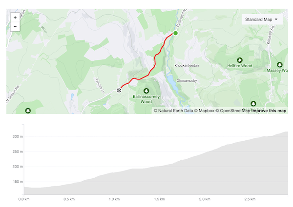
The western approach to Wicklow Gap is undeniably the less attractive option. It lacks any clear starting point: arguably the R756 starts to rise eleven kilometres away, at the bridge across the King’s River below the Hollywood hills, but only when you’re halfway to the Gap does the gradient become visible. You’re definitely already climbing by the time you reach the Quintagh turn-off, but it offers one of the few obvious landmarks on a long, wide road.

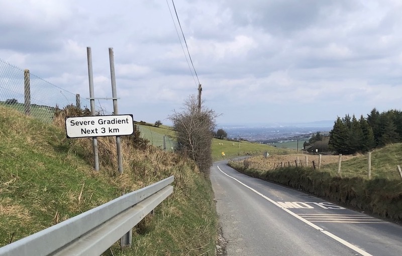
For all that road is wide, the lower reaches of the climb are closed in by trees and hillside, and there’s no view to speak of until you’re close to the top, the ground falling away to your right revealing the line of pylons leading up to the ESB station. By then the hardest parts of the climb are behind you, and you can pick up speed as you approach the summit.

For all that, it’s a good climb for early in the year. By whatever quirk of local climate, conditions around Wicklow Gap are generally more forgiving than Sally Gap — you’re less exposed to the gales which in any case funnel up the valley, pushing you up the road. As the main east-west route across the mountains, the road is well-maintained and gets enough sun that frost clears quickly. The gradient is never severe, maxing out at 8–9%, and it’s long enough an effort to build endurance when you’re laying down your base miles.

But the reward really comes with the descent to Laragh on the other side: a wide-open road that swings smoothly around the mountainside, offering clear visibility of any approaching traffic. It’s largely free of potholes and gravel, and confident descenders will take it like a luge run.

A wide road rising and swing left over a mountain pass under scattered cloud
The final metres…the barely visible signposts mark the top

Ballinascorney (2.9km, 191m, 6.3%)

Map and elevation profile of Ballinascorney climb

Strava

Ballinascorney is a solid climb but it doesn’t inspire genuine love in me. The lower section is nice, winding upwards on a smoothly paved, tree-lined road, but it’s also very narrow, and the quarry at the top of the hill means that you often find yourself being monstered by impatient gravel truck drivers. Further up the road opens out but the surface is harsher and you’re more exposed to the wind.

Nonetheless, I ride it dozens of times every year, and I’m often battling it out for the Local Legend on the Strava segment because it’s the best way out of the city towards the south-west. The Embankment (N81) will take you to many of the same places but traffic is far heavier and there’s no hard shoulder despite it being an N-road. Ballinascorney gives you access to the picturesque roads behind Bohernabreena reservoir, and to essential climbs like the Firing Range and McDonagh’s Lane. It’s usually salted in the winter and carries enough traffic for any frost to melt off quickly so it’s often usable when other mountain roads aren’t.

The road starts climbing as you pass the Bohernabreena Reservoir car park and if you’re lucky enough not to have any cars for company the first kilometer or so is very pleasant. It briefly hits 14% but the road is so smooth that you’d barely notice it. There’s a respite section as you pass the foot-golf course on the left before the road kicks up again and the surface turns into giant sandpaper. The next half-kilometer is the meat of the climb, a steady 9% gradient. The gradient eases off as you swing left and you’d like to shift up but this is usually the moment when you discover where the wind has been hiding, and you crawl the remaining 500m to the top.

I wish you the very best of luck in stealing Nico Roche’s KOM on this segment.

Road sign warning of "Severe Gradient Next 3km" next to road, Dublin visible in the background
Brother, have you heard the good news?

Ballinascorney comes into its own as a descent. At the crest of the hill you get a brief glimpse of the city spread out below you* as you get into full aero tuck for the ski-slope first half. The lower half is more sinuous and narrow but the curves are still loose enough that you can rip through them faster than cars can drive them. After the shank over the bridge at the bottom of the descent proper the road continues gently downhill all the way back to Rathfarnham and you often have a tailwind into the bargain — you may have been on your hands and knees before then but you’ll feel like a king, big ringing it all the way home.

*Like a patient etherized upon a table.