Bishopshill (84km, 992m)

Map of Bishopshill route

RideWithGPS

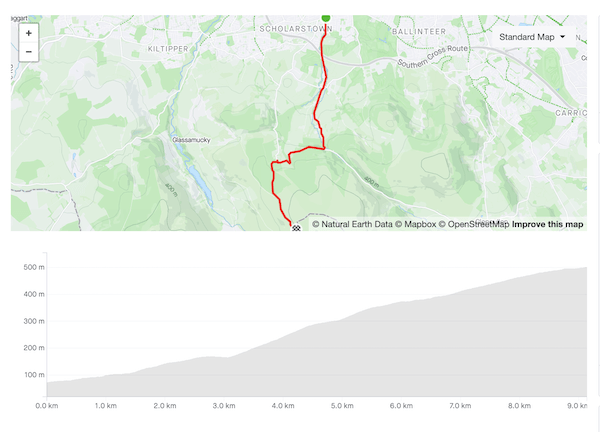
Categorised Climbs: Ballinascorney, McDonagh’s Lane, Bishopshill Road

A five-star route: classic climbs, quiet roads, beautiful scenery. There are very few routes in the Dublin area which pack so much into a ride you can finish before lunchtime. This is my Ardennes Week route — maybe there’s nothing here to match the Mur de Huy or La Redoute but there are punchy ramps steep enough to get your attention.

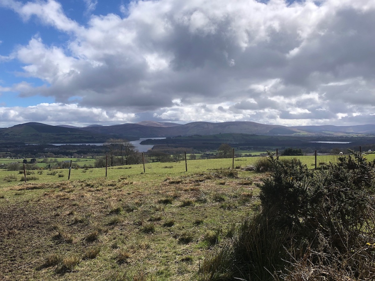
The early section following the R114 over Ballinascorney to Brittas is fairly routine, but provides a good warm-up for the ascent of McDonagh’s Lane that awaits on the far side of the N81. Follow the road around the back side of Slade Valley and along the ridge before dropping down to a crossroads. Turn left for Kilteel and Eadestown. This is the westernmost edge of the Dublin mountains — to your right only the flat expanse of the midlands. The few hills visible on the horizon are a couple of counties away.

A few kilometres after Eadestown, the road begins to rise, presaging the final categorised climb of the day, Bishopshill Road. The steep ramps on the lower reaches of the climb are more than compensated by the views of Poulaphouca reservoir and Blessington from the top. Drop down into Ballymore Eustace, and up to the N81, before making a quick loop around Tulfarris and returning to Dublin via Blessington, Manor Kilbride and Ballinascorney.

There are few hazards along the way: the descent after Slade Valley is steep and badly paved but doesn’t see much traffic so you can usually pick your way down without trouble. Best taken handy, nonetheless. You’re on the N81 for a stretch coming into Blessington but it’s flat, well-paved, and you often have a tailwind so it passes quickly.

There is scope for variation: if you want a shorter route, turn left at the T-junction at 36km (after Bishopshill) to cut straight back to Blessington. This lops nearly 20km off the route although you’re missing a lot of pleasant cycling by the reservoir. You can take a different look at the hill by continuing past Bishopshill Road and taking the next left instead — you miss some of the views but it’s a steadier climb. And if the R114 is getting you down, you can take the road up Mount Seskin to Brittas instead.

The view from Bishopshill Road: Poulaphouca reservoir with the Wicklow mountains in the background, underneath a partly blue, partly cloudy sky
Worth waiting for: Poulaphouca nestled beneath the mountains

Edmondstown Road (9.1km, 432m, 4.7%)

Map and elevation profile of Edmondstown Road climb

Strava

Edmondstown Road and Stocking Lane are the fraternal twins of the Dublin Mountains, two climbs connecting the same two points, recognisably related but each with its own distinct character. Of the two, Edmondstown Road is the longer and gentler, and the option I prefer at the start of longer rides — the steep ramp on Stocking Lane can deaden the legs if you’re out of shape. But they’re both terrific, and you can substitute them as the moment takes you on any route heading out along the Military Road.

The climb proceeds upwards in steps—an initial gentle rise to Edmondstown golf club flattens to pass under the M50, then becomes steeper as you pass the Merry Ploughboy. There’s another respite section after the turn-off for Mount Venus Road, dropping down a few metres to the longest ramp: 1.4km varying between 8–11%. The road winds left and right under the trees until you shank left over a small bridge, then right past the turn-off for Glencullen.

The gradient eases off, but the road surface deteriorates, the council having taken a distinctly (perversely, one might say) piecemeal approach to repaving the road. Passing the entrance to Cruagh Woods, you say goodbye to double-digit gradients, then make a couple of hairpins to arrive at the Viewing Point.

If this is your very first time there, it is acceptable to join the crowds taking selfies with the city in the background. Otherwise, take the sharp left onto Military Road and keep going. The last 2.5km ease gradually from 7% down to 2% as you approach the Noel Lemass memorial, but the road is well-surfaced to the county line, and you’ll be held back more by the wind which will hit you as soon as you emerge from the trees.

The descent is just as enjoyable as the climb, straight and  blazing fast in parts, technical in others. Keep your wits about you as pass the Cruagh Woods car park—particularly on weekends and holidays, you’ll often encounter drivers engaged in emergency manoeuvres, and stray dogs or children.

The view from Cruagh Road: green fields dropping away under partly cloudy skies, Dublin city and bay visible in the background.
The view from Cruagh Road